-
Clean Colorado Sustainability Coalition
2330 McCulloch Blvd. N.
Lake Havasu City, AZ 86403
Phone: (928)453-4152
contact
Lower Colorado River Watershed Hydrology, River Environments, and Chemistry
River Physical Characteristics
The Colorado River on the Colorado Plateau above Lake Mead has a steep gradient dropping almost 2500 feet in elevation from Lee's Ferry 350 miles upriver (Figure 1). The flow through the Grand Canyon is swift with many rapids. Conversely, the profile of the river south of Lake Mead is much more languid with an elevation drop of less than 800 feet to the Southern International Border with Mexico almost 350 miles downstream. Furthermore, two other reservoirs south of Lake Mead, Lake Mohave and Lake Havasu, break up the flow of the lower stretch of the river. These contrasting flow regimes have implications on how introduced contaminants may behave. Faster, more turbulent flowing water will transport pollutants down river very quickly, whereas slower moving river reaches may cause contaminants to linger at any given location.
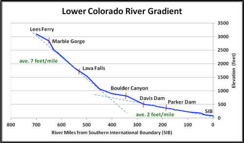
Figure 1: Colorado River elevation drop from Lees Ferry just down river from Glen Canyon Dam (Lake Powell) to Boulder Canyon (Lake Mead). This drop has an average gradient of 7 feet / mile. The elevation drop from Hoover Dam (lake Mead) to the Southern International Border with Mexico is much more subdued with an average of 2 feet / mile.
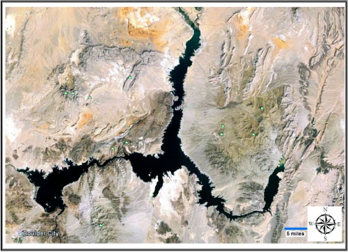
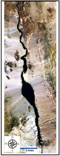
A mix of shallow canyons and broader alluvial floodplain valleys containing associated wetlands lie along the Lower Colorado River and its constructed reservoirs. Small mountain ranges typically accompany the shallow canyon reaches and satellite imagery highlights active river channel movement within floodplain areas (Figure 3) that are not inundated (e.g. Lake Mohave and Lake Havasu).
Only two perennial tributaries occur along the Lower Colorado River, the Bill Williams and Gila Rivers. Both typically contribute a limited amount of water to the Colorado River. The Bill Williams River usually contributes water to Lake Havasu through subflow, except during intense, local storm precipitation when flood waters also contribute a significant amount of sediment. A large delta from the river with a thick cattail and bulrush surface is present in the lake. The Gila River contribution is small because intense agricultural irrigation up river from its confluence with the Colorado River diverts much of its water.
There are many ephemeral streams intersecting the Colorado River. Many are small and result from the relatively steep gradient from alluvial fan surfaces sloping away from adjacent mountain ranges. A few, such as Sacramento Wash near I-40 in Mohave County, Arizona have a much more extensive watershed area that occasionally contribute significant storm water runoff and sediments to the river system.
Reservoirs
The three primary reservoir on the Lower Colorado River are Lake Mead, Lake Mohave and Lake Havasu. These reservoirs lie behind the permanent dams of Hoover, Davis and Parker, respectively. Lake Mead (Figure 2) is the largest reservoir in the United States at 158,000 acres with a maximum holding capacity of over 26 million acre-feet (an acre-foot is equal to 325,851 gallons). The Southern Nevada Water Authority annually diverts over 300,000 acre-feet of water from the reservoir. Lake Mead is the reservoir that is most closely watch for its water elevation as it serves as the guidepost on which shortages may be declared by the Secretary of the Interior (the Watermaster of the river system).
Lake Mohave (28,000 acres; 1.8 million acre-feet) and Lake Havasu (19,300 acres; 620,000 acre-feet) are considerably smaller and except for slower flow velocities, are more like long, wide stretches of the river (Figures 3 and 4). Both act as detention basins, temporarily holding water to help regulate water flow from Hoover Dam released for water orders down river of Lake Havasu. During the summer months when agricultural irrigation demand is very high, water volumes equal to Lake Havasu's capacity may go through the system in as little as 17 days. This dynamic is important to consider with respect to water quality issues on the river system.
Water elevations in Lake Mohave and Lake Havasu are kept within a narrow range (less than 10 feet), for balancing water orders and protecting diversion points, respectively. Two of the three largest water diversion points on the Lower Colorado River are located at the southern end of Lake Havasu. The Metropolitan Water District of Southern California, the primary agency that funded the construction of Parker Dam (completed in 1939), diverts up to 1 million acre-feet per year for urban and agricultural use in southern California. The much newer Central Arizona Project diversion point (pumping began in the late 1980's) provides up to 1.6 million acre-feet to central and southern Arizona urban and agricultural interests.
There are several small diversion dams down river of Parker Dam that are used to re-route water away from the river to various agricultural irrigation and drainage districts in California and Arizona. These include Headgate Rock Dam, Palo Verde Dam, Imperial Dam, Laguna Dam, and Morelos Dam. Imperial Dam is the location of the largest diversion point on the Lower Colorado River. Water is transferred to the Imperial Irrigation and Drainage District via the All American Canal. None of the diversion dams back up an appreciable amount of water, although the section of river between Headgate Rock Dam and Parker Dam is locally called Lake Moovalya.
The three main reservoirs experience seasonal heating that cause spring and summer stratification of the water column. A metalimnion, a narrow zone of rapid temperature change, separates overlying warmer water of the epilimnion zone from underlying colder water of the hypolimnion zone (Figure 5). These zones of different water density keep the water from mixing, effectively isolating water in the hypolimnion. Cooler air temperatures in the autumn begin to cool the surface water, weakening and eventually erasing the stratification. This process is known as overturning, which thoroughly mixes the water so that the water temperature and other physical properties remain the same throughout the water column (Figure 6). These seasonal differences have a profound effect on chemical transport and distribution, including nutrients like phosphorus.
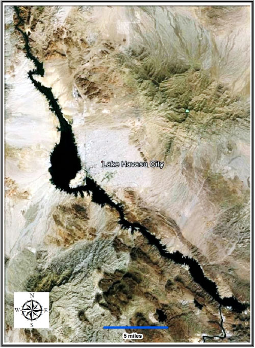
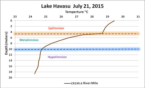
Figure 5: Summer temperature profile of Lake Havasu at river mile 199.6 from the Southern International Border illustrating lake stratification.
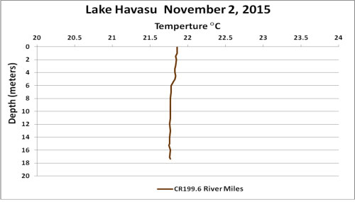
Figure 6: Fall temperature profile of Lake Havasu at river mile 199.6 from the Southern International Border illustrating uniform conditions from surface to lake bottom.
Water Chemistry
Colorado River water, at least as measured in Lake Havasu, has a hydrochemical signature (i.e. water chemistry type as determined by the major ions in the water - sulfate, chloride, bicarbonate, calcium, sodium, potassium, magnesium) in which no one ion type dominates. It is more of a mix of calcium and sulfate / chloride than the other ions. These ions can originate from multiple sources, both geologic and human derived. The Total Dissolved Solids content or salinity is moderately high for fresh water (500-600 parts per million (mg/L)) in the river stretch from Lake Mead to Lake Havasu. The TDS only increases down river (Figure 7), which is why the Federal Government passed the Salinity Control Act in 1974 to help keep saline water from impacting Mexico's entitlement. The water hardness is above 280 parts per million (mg/L).
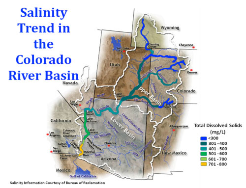
Figure 7: The salt content of the river, express as total dissolved solids, increases as the water is used and returned to the river and as evaporation increases on the river from the Rocky Mountains to the low desert environment.
From a nutrient standpoint, the Lower Colorado River is considered phosphorus limited as compared to the levels of nitrate in the water. This has implications to algal growth in the reservoirs, which can be a major nuisance. However, this stretch of the river needs more research to quantify nutrient loading and cycling.
Certain minor and trace elements such as arsenic, barium, boron, fluoride, manganese, and selenium are regularly detected at low concentrations in the river and reservoirs. Both natural and human derived sources contribute to their presence in the river system. The geology within the Colorado River Basin is highly varied so that certain elements may be weathered from different rock types, such as shale in the upper basin (selenium), volcanic rocks in the lower basin (fluoride, boron, manganese) and sedimentary rocks in both basins (barium). However, urban and industrial sources also contribute elements and compounds to the river through surface runoff during rain events. Examples of compounds in the river not originating from natural sources are hydrocarbons and emerging contaminants (e. g. pharmaceuticals, personal care products and industrial compounds). Past work has shown all these present in ultra low concentrations with many originating from wastewater treatment plant out flows as well as from water-related recreational activities.
Aquatic Biology
A variety of habitats or environments occur within the river/reservoir system. River stretches typically consist of free flowing water, but without rapids. Some reaches contain shallow coves, many where drainages used to intersect the river channel prior to dam construction. There are also extensive wetlands, such as at Topock Marsh north of I-40 and multiple smaller marshes along the river south of Parker, AZ, that contain back water ponds and slews. The reservoirs consist of shallow (<20 feet) and deep (>50 feet) open water environments and bays/coves with marshy fringes (cattails and bulrushes) along their margins that shelter a variety of fish and wildlife.
Microorganisms:
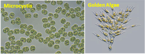
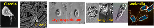
The Lower Colorado River contains microorganisms typically present in almost all other river/reservoir systems. Those of concern include golden algae and Microcystis (Figure 8)as well as the micropathogens E. coli, Cryptosporidium, Legionella, Giardia, and Naeglaria fowlleri (Figure 9).
Native fish
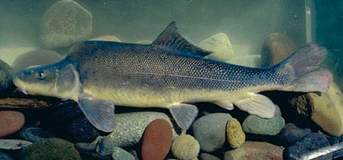
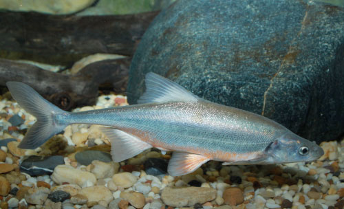
There are two main endangered fish species in and below Lake Mead, razorback sucker and boney-tailed chub (Figures 10 and 11). Federal and state biological agencies have worked many decades to help restore these species. A major program in effect to protect these and other endangered species is the Lower Colorado River Multispecies Conservation Program, a multi-partner, federal, state and local effort lead by the Bureau of Reclamation to restore and protect critical habitat.
For more details on the efforts of saving these fish, please visit the Endangered Razorback Sucker Program page at the Bureau of Reclamation site or read the pdf by the Lower Colorado Multi-Species Conservation Program titled Native Fish Augmentation Plan.
Introduced Game Fish
Dozens of sport fish species have been purposely introduced in the Lower Colorado River to enhance recreational opportunities and bolster local economies. Several of these sport fish (large and small mouth bass, striped bass, etc.) pose an obstacle to growing the native fish population as the former eat the young of the latter. Steps have been taken to adequately grow the endangered fish species before release so they have a better chance of survival. One present sport fish of interest is the red-eared sunfish, which is known to eat quagga mussels (see invasive species below). Artificial fish habitat structures have been deployed in Lake Havasu and Lake Mohave coves and bays to help enhance fish populations.
The following publications provide a list of known present species in the Colorado River.
Invasive Species
Many species have been introduced in the Lower Colorado River both intentionally such as the sport fish mentioned above and accidentally as in the case of quagga mussels, New Zealand mud snails, Corbicula clams, spiny naiad, sago pond weed, Eurasian watermilfoil, and gizzard shad. These species may occupy the same habitat as species already in place and may outcompete them for local resources and displace them. A notable example is the quagga mussel which very efficiently filters the water for plankton and can proliferate very quickly. The result is their explosive occupation of a reservoir and man-made structures within that need expensive maintenance. There are several groups that meet periodically to discuss Lower Colorado River invasive species issues; The Lower Colorado River Aquatic Invasive Species Task Force, the Interagency Quagga Mussel group, the Lake Mead Ecosystem Monitoring Workgroup, and the Colorado River Aquatic Biologist group.
Invasive aquatic and riparian plant species (such as Tamarisk and arundo donax) have also impacted the Lower Colorado River, affecting boat navigation, water diversion intakes and water quantity on the river. More discussion on this topic is given under the threats tab.

Water Quality Monitoring Programs
There are several entities that conduct water quality monitoring programs on the Lower Colorado River. The major regional water provider agencies, SNWA, MWD and CAP, collect water samples for chemistry, physical parameters and biological activity. SNWA is most focused on Lake Mead and Lake Mohave and since these two reservoirs are within the Lake Mead National Recreational Area, they work closely with the National Park Service.
MWD and CAP collect samples on Lake Havasu near their diversion points. MWD also extends its monitoring up river to near Topock. The Bureau of Reclamation, Chemehuevi Tribe and Arizona Department of Environmental Quality also have established monitoring programs on Lake Havasu. The Colorado River Indian Tribe south of Parker, Arizona monitors the stretch of river that flows through their reservation. Much of the information collected is accessible in the water quality data base hosted by SNWA.