-
Clean Colorado Sustainability Coalition
2330 McCulloch Blvd. N.
Lake Havasu City, AZ 86403
Phone: (928)453-4152
contact
Monitoring
Lower Colorado River Water Quality Monitoring
Water quality monitoring efforts have occurred along the Lower Colorado River (LCR) by various regional, state, tribal and federal entities for several decades, yet many efforts were historically conducted without much interaction with other groups collecting data. The USEPA, U.S. Geological Survey, the U.S. Fish and Wildlife Service, and the Arizona Department of Environmental Quality (ADEQ) have funded focused academic investigations or have directed studies covering Lower Colorado River water toxicity, characterization of surface water nutrient, emerging contaminant, perchlorate, selenium, mercury and heavy metal concentrations, and the effects of selected contaminants on fish and aquatic wildlife. Many publications and white papers resulted from this work that give a sense of the environmental concerns that have received attention on the LCR (see a partial list of references at the end of this section).
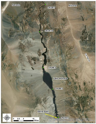
In 2008 CCRSCo began discussions with the Bureau of Reclamation (Reclamation), a non-voting participating partner, to gather existing surface water quality data south of Lake Mead and organize it into a comprehensive database for easier access by all parties and the public. In addition, Reclamation would begin water quality monitoring in Lake Havasu. The Southern Nevada Water Authority (SNWA) and the National Park Service (NPS) had already begun collecting water quality data in Lake Mohave, which is still ongoing (Figure 1).
A cooperative agreement between CCRSCo and Reclamation was signed in 2009. The main points of the agreement included:
- 1) Reclamation would budget and implement a water quality data collection survey in Lake Havasu for at least seven years;
- 2) CCRSCo members would search for and submit existing water quality data within the LCR. In addition, any available groundwater quality data from wells adjacent to the river system would also go into the database; and
- 3) SNWA would expand their existing water quality database to include a section for the LCR. They would also provide a service for access to the database (see the Resource Tab section).
The database was populated with a large amount of data from ADEQ, Metropolitan Water District of Southern California (MWD), Reclamation, U. S. Geological Survey, Central Arizona Project (CAP), Bureau of Land Management, and Lake Havasu City. Part of Reclamation’s data contribution includes localities south of Lake Havasu to the southern International Border.

|

|
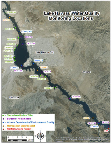
| Figure 1: Lake Mohave SNWA sample monitoring sites. | Figure 2: Current water quality sample locations in Lake Havasu by various entities. |
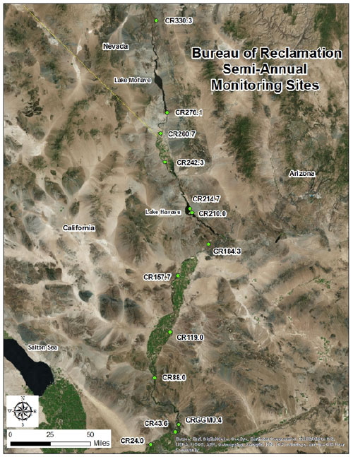
Reclamation continues its water quality monitoring in Lake Havasu (Figure 2) and they have seven sample sites on the lake which are visited every other month. They also continue to sample semi-annually along the length of the LCR (Figure 3). ADEQ, through an informal agreement with Reclamation, collects water quality information from Lake Havasu in the months not included in the Reclamation schedule. MWD, the Chemehuevi Tribe, and CAP continue to collect monthly water quality information in Lake Havasu (Figure 2). In addition, Lake Havasu City with funding from the Bureau of Land Management conducted a 5-year study from 2012 to 2016 of stormwater runoff water quality from the city into Lake Havasu. This work included analyzing shallow groundwater and shoreline and lake bottom sediments in an effort to identify the fate of runoff constituents and calculate the amount of nutrient loading into the reservoir.
The types of data collected for the lake/river monitoring program include physical and chemical properties of water and a biological assessment of the food chain base - aka, plankton. Methods used include: electronic multiprobes to measure water temperature, pH, dissolved oxygen, conductivity, oxidation-reduction potential at various depths, Secchi Disk water clarity measurements, multi-depth water samplers for water chemistry, surface water samples for both water chemistry and phytoplankton, and plankton tow nets for zooplankton. The analysis of cyanotoxins from surface water was added in 2015 in response to expanded Microcystis growth in all three reservoirs that year.
 |
| Figure 3: Bureau of Reclamation Lower Colorado River water quality monitoring sites that are sampled twice each year for many water quality parameters, including emerging contaminants. |
The Lake Mohave monitoring work by SNWA and NPS includes five locations (see map) examined using the same types of methods. Water quality sample analyses are also conducted by the Colorado River Indian Tribe south of Parker as the Colorado River flows through their tribal land.
Water quality parameters that are included in at least one of the above monitoring programs:
CCRSCo Funding Efforts
CCRSCo funded an effort in 2008, through the consulting firm PBS&J, to identify and summarize perceived water quality issues and to give an update on capital improvement projects (CIP) related to water quality on the LCR. The resulting white paper outlined costs, prioritized criteria for and identified potential CIPs as well as highlighted specific contaminant concerns in the LCR (to access the report, see the Documents Section).
In January 2016, CCRSCo awarded to Arizona State University Colleges at Lake Havasu, a $10,000 grant to conduct a bathymetric and 3-D imaging survey of Lake Havasu’s bottom. The purpose of this work is multifold, including establishing the geometry or shape of the lake for computer modeling of water flow entering and exiting the reservoir, to map the old riparian corridor of snags that still exist underwater, to identify areas of aquatic vegetation not at the lake’s surface, to map historical and cultural features at the bottom of the lake and to help assess conditions to artificial fish habitats deployed in the reservoir. A similar effort led by the National Park Service was recently conducted for Lake Mohave.
Selected Publications and White Paper Documents
- Andrews, B. J., King, K. A., and Baker, D. L., 1997, Environmental contaminants in fish and wildlife of Havasu National Wildlife Refuge, Arizona: U.S. Fish and Wildlife Service Region 2, Contaminants Program, Project ID 22410-1130-2N17, 70 p.
- Boyd, R. A. and Furlong, E. T., 2002, Human-health pharmaceutical compounds in Lake Mead, Nevada and Arizona, and the Las Vegas Wash, Nevada, October 200-Agust 2001: U.S. Geological Survey Open-File Report 02-385, 18 p.
- Jones-Lepp, T. L., Sanchez, C., Alvarez, D., Wilson D. C., Taniguchi-Fu, R-L, 2012, Point sources of emerging contaminants along the Colorado River Basin: Source water for the arid Southwestern United States: Science Total Environment, Vol. 430, pp. 237-245.
- King, K. A., Baker, D. L., Kepner, W. G., and Martinez, C. T., 1993, Trace elements in sediment and fish from National Wildlife Refuges on the Colorado River: U.S. Fish and Wildlife Service Region 2, Contaminants Program, 21 p.
- Lico, M. S. and Johnson, B. T., 2007 Gasoline-related compounds in Lakes Mead and Mohave, Nevada, 2004-06: U. S. Geological Survey Scientific Investigations Report 2007-5144, 28 p.
- Lower Colorado River watershed quality update: 2009, white paper prepared by PBS&J for Colorado River Regional Sewer Coalition, 32 p.
- Lower Colorado River Water Quality Partnership, undated white paper hosted by the Central Arizona Project, 13 p. http://www.cap-az.com/documents/departments/planning/colorado-river-programs/LCRQP-White-Paper.pdf
- Marr, C. H. and Velasco, A. L., 2005, Arizona backwater manipulations for Endangered Fishes: Management implications of selenium on National Wildlife Refuges of the Lower ColoradO River., U.S. Fish and Wildlife Service Region 2, Environmental contamination program on-refuge investigation sub-activity, Project ID 22410- 1261-2N37, 64 p.
- Martinez, C. T., 1994, Selenium levels in selected species of aquatic birds on Imperial National Wildlife Refuge: M. S. Thesis, University of Arizona, 74 p.
- Radtke, D. B., Kepner, W. G., and Effertz, R. J., 1988, Reconnaissance investigation of water quality, bottom sediment, and biota associated with irrigation drainage in the Lower Colorado River Valley, Arizona, California, and Nevada, 1986-1987: U. S. Geological Survey Water-Resources Investigation Report 88-4002, 77 p. Recommendations to address Colorado River water quality: 2005, Clean Colorado River Alliance, white paper commissioned by Arizona Governor Janet Napolitano and sponsored by the Arizona Department of Environmental Quality, 110 p.
- Slawson Jr., G. C., 1972, Water quality in the Lower Colorado River and the effect of reservoirs: University of Arizona, Department of Hydrology and water Resources Report No. 12, 118 p.
- Tietjen, T., Holdren, G. C., Rosen, M. R., Veley, R. J., Moran, M. J., Vanderford, B., Wong, W. H., and Drury, D. D., 2011, Lake water quality; Chapter 4 in Rosen, M. R., Goodbred, S. L., and Miller, J. M., eds., A synthesis of Aquatic Science for Management of Lakes Mead and Mohave, U.S. Geological Survey Circular 1381, 162 p.
- Wilson, D. C., McMaster, H. A., Kirsch, J. E., and Walker, D. B., 2016, 2014-2015 Microcystis Outbreak in Lake Havasu: [ab.] Lower Colorado River Science Symposium 2016, Nevada Division of Environmental Protection, Las Vegas, p. 6-7.
- Wilson, D. C., 2016, Nutrients in stormwater runoff and distribution in Lake Havasu: Lower Colorado River Science Symposium 2016, Nevada Division of Environmental Protection, Las Vegas, p. 6.
- Wong, W. H., Holdren, G. C., Tietjen, T., Gerstenberger, S., Moore, B., Turner, K., and Wilson, D. C., 2014, Effects of invasive quagga mussels (Dreissena rostriformis bugensis) on chlorophyll and water clarity in the lower Colorado River: in “Quagga and Zebra Mussels: Biology, Impact, and Control, 2nd Edition” Edited by T.F. Nalepa & D.W. Schloesser, CRC Press, Boca Raton, FL, p. 495-508.